
About Plots in DAMAC Communities at DAMAC Hills, Hills 2, Lagoons, Islands & Riverside, Dubai
Plots in DAMAC Communities sets out the school and mixed-use plots shown in a DAMAC master-plan study (Schools Study - DAMAC Master Plans, V03) for DAMAC Hills, DAMAC Hills 2, DAMAC Lagoons, DAMAC Islands and DAMAC Riverside: plot areas, permitted gross floor area (GFA), floor area ratio (FAR), heights and land uses.
The study shows nine plots: eight school plots (one each in DAMAC Riverside and DAMAC Islands, two each in DAMAC Lagoons, DAMAC Hills and DAMAC Hills 2) and one mixed-use plot in DAMAC Hills 2 for retail, a clinic, a private hospital and apartments. Where a detailed plot sheet exists, this page uses its exact figures; otherwise the rounded community summary figure.
Most school land: DAMAC Hills 2, about 97,013 sq m (about 1.04 million sq ft) across two plots, followed by DAMAC Lagoons at about 92,960 sq m. Largest single school plot: DAMAC Hills 2 School 1 at 74,012 sq m.
Important: these are community facility plots reserved in master plans, not residential plots for sale. A plot reserved for a school, clinic or hospital does not mean the facility is open, under construction, licensed or scheduled to open. The study is undated on its face; the DDA plot sheets it reproduces are dated 13 January 2025. Population figures are planning figures, not current resident counts.
Register Your Interest — Priority Access
Plots in DAMAC Communities is launching soon. Register now to be among the first to access units, pricing and the payment plan ahead of the official launch.
Priority allocation before the official launch · 0% buyer commission · RERA certified (ORN 43954).
Plots in DAMAC Communities Gallery
11 Photos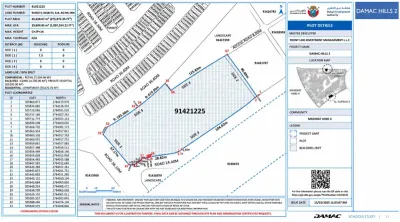
All Plots in DAMAC Communities at a Glance
One row per plot. Where a plot sheet exists, figures are exact and come from that sheet; other figures come from the rounded community summary page. Square feet converted at 1 sq m = 10.7639 sq ft unless the DDA sheet prints its own figure.
| Community & plot | Land use | Plot area (sq m) | Plot area (sq ft) | Max GFA (sq m) | FAR | Max height | Source |
|---|---|---|---|---|---|---|---|
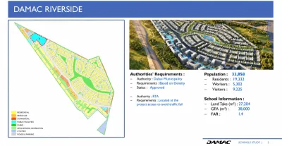
| DAMAC Riverside - school plot | School | 27,204 | 292,821 | 38,000 | 1.40 | Not stated | Summary p. 2 |
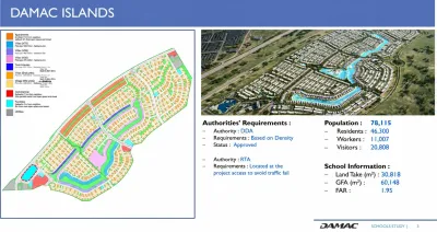
| DAMAC Islands - school plot | School | 30,818 | 331,722 | 60,148 | 1.95 | Not stated | Summary p. 3 |
| DAMAC Lagoons - SCH-01 | School | 46,473.06 | 500,232 | 30,000 | 0.65 | G+3 | Plot sheet p. 5 |
| DAMAC Lagoons - SCH-02 | School | 46,487.34 | 500,386 | 30,000 | 0.65 | G+3 | Plot sheet p. 6 |
| DAMAC Hills - School 1 | School | 36,288.37 | 390,605 | 23,073.66 | 0.64 | G+3 | DDA sheet p. 8 |
| DAMAC Hills - School 2 | School | 33,042 | 355,661 | 24,956 | 0.76 | Not stated | Summary p. 7 |
| DAMAC Hills 2 - School 1 | School | 74,012 | 796,659 | 53,121 | 0.72 | Not stated | Summary p. 9 |
| DAMAC Hills 2 - School 2 | School | 23,001.42 | 247,585 | 16,531.80 | 0.72 | G+3 | DDA sheet p. 10 |
| DAMAC Hills 2 - mixed-use plot | Retail, clinic, private hospital, apartments | 25,638.67 | 275,972 | 93,604.85 | 3.65 | G+2P+14 | DDA sheet p. 11 |
FAR is GFA divided by plot area; where plot-sheet figures are used, FAR is calculated from them.
School Land Totals by DAMAC Community
Population is the planning figure printed in the study, not a verified current population. Only DAMAC Riverside and DAMAC Islands split it into residents, workers and visitors.
| Community | Reported population | School plots | School land (sq m) | Study printed total (sq m) | School GFA (sq m) | Source pages |
|---|---|---|---|---|---|---|
| DAMAC Riverside | 33,858 | 1* | 27,204 | 27,204 | 38,000 | 2 |
| DAMAC Islands | 78,115 | 1* | 30,818 | 30,818 | 60,148 | 3 |
| DAMAC Lagoons | 57,939 | 2 | 92,960 | 84,046 | 60,000 | 4-6 |
| DAMAC Hills | 41,410 | 2 | 69,330 | 69,331 | 48,030 | 7-8 |
| DAMAC Hills 2 | 67,690 | 2 | 97,013 | 97,014 | 69,653 | 9-11 |
School land adds the plot figures above. *For DAMAC Riverside and DAMAC Islands the study shows one outlined plot and one land figure but does not state how many schools it is for.
DAMAC Riverside School Plot
DAMAC describes DAMAC Riverside as located in Dubai Investments Park. The summary page (PDF p. 2) is the only one in the study that names Dubai Municipality, rather than DDA, as the planning authority. No plot sheet is included.
| Figure | Reported in the study |
|---|---|
| Reported population | 33,858 |
| Residents / workers / visitors | 19,332 / 5,302 / 9,225 |
| School plot area | 27,204 sq m (292,821 sq ft) |
| School GFA | 38,000 sq m |
| FAR | 1.4 |
| Dubai Municipality requirement | Based on density - status shown as Approved |
| RTA requirement | Located at the project access to avoid traffic problems |
Approved refers to the density-based planning requirement only. It does not show that a school building, operator or education licence has been approved.
DAMAC Islands School Plot
DAMAC lists DAMAC Islands in Dubailand. The summary page (PDF p. 3) has the largest planning population in the study and the highest school FAR. No plot sheet is included.
| Figure | Reported in the study |
|---|---|
| Reported population | 78,115 |
| Residents / workers / visitors | 46,300 / 11,007 / 20,808 |
| School plot area | 30,818 sq m (331,722 sq ft) |
| School GFA | 60,148 sq m |
| FAR | 1.95 |
| DDA requirement | Based on density - status shown as Approved |
| RTA requirement | Located at the project access to avoid traffic problems |
DAMAC Islands 2 is marketed by DAMAC as a separate community and is not covered by the study, so these figures should not be applied to it.
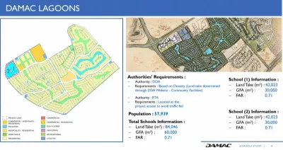
DAMAC Lagoons School Plots
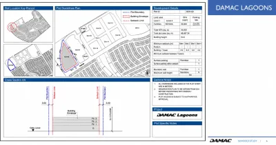
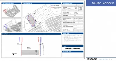
Two adjoining school plots (PDF p. 4), each with a detailed plot sheet (pp. 5-6): Facilities - School land use, G+3, 3 m setbacks on all sides, parking as per DDA standards. A demarcation plan must be obtained from DDA before design or construction. Reported population: 57,939.
| Plot | Plot area (sq m) | GFA (sq m) | FAR | Height |
|---|---|---|---|---|
| SCH-01 | 46,473.06 | 30,000 | 0.65 | G+3 |
| SCH-02 | 46,487.34 | 30,000 | 0.65 | G+3 |
| Total | 92,960.40 | 60,000 | 0.65 |
The study summary page lists a smaller land take of 42,023 sq m per plot (84,046 sq m in total, FAR 0.71). The plot-sheet areas are used here as the more detailed source.
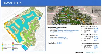
DAMAC Hills School Plots
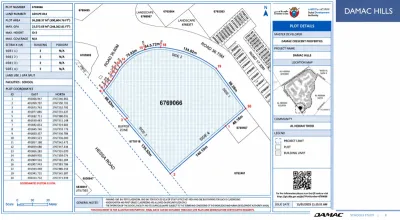
Two school plots (PDF p. 7). The DDA plot details sheet for School 1 (p. 8, issued 13 January 2025) gives plot 6769066 in Al Hebiah Third, beside Hessa Road: 36,288.37 sq m (390,604.76 sq ft), max GFA 23,073.66 sq m, G+3, 3 m setbacks. Reported population: 41,410.
| Plot | Plot area (sq m) | GFA (sq m) | FAR | Source |
|---|---|---|---|---|
| School 1 | 36,288.37 | 23,073.66 | 0.64 | DDA sheet p. 8 |
| School 2 | 33,042 | 24,956 | 0.76 | Summary p. 7 |
| Total | 69,330 | 48,030 | 0.69 | Study prints 69,331 sq m, FAR 0.7 |
The DDA sheet notes that kindergarten and first-grade classrooms are allowed on the ground floor only, that school operation and curriculum are subject to KHDA, and that it is for illustration - final data comes from site plan and demarcation certificate requests.
DAMAC Hills 2 School Plots
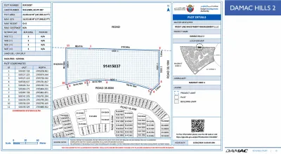
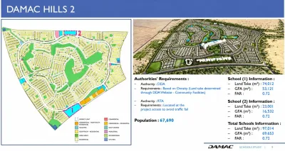
Two school plots (PDF p. 9), the most school land in the study. The DDA plot details sheet for School 2 (p. 10, issued 13 January 2025) gives plot 91415037 in Madinat Hind 4: 23,001.42 sq m (247,585.22 sq ft), max GFA 16,531.80 sq m, G+3, 3 m setbacks. Reported population: 67,690.
| Plot | Plot area (sq m) | GFA (sq m) | FAR | Source |
|---|---|---|---|---|
| School 1 | 74,012 | 53,121 | 0.72 | Summary p. 9 |
| School 2 | 23,001.42 | 16,531.80 | 0.72 | DDA sheet p. 10 |
| Total | 97,013 | 69,653 | 0.72 | Study prints 97,014 sq m |
The School 2 sheet carries the same notes on KHDA conditions, ground-floor kindergarten classrooms and its illustrative status.
DAMAC Hills 2 Mixed-Use Plot: Retail, Clinic, Private Hospital and Apartments
DDA plot 91421225 in Madinat Hind 4 (PDF p. 11, issued 13 January 2025): plot area 25,638.67 sq m (275,972.35 sq ft), max GFA 93,604.85 sq m (1,007,554.22 sq ft), FAR 3.65 (calculated), max height G+2P+14, 7.5 m building setback on one side.
| Land use | GFA (sq m) | Share |
|---|---|---|
| Residential - apartments | 70,670.76 | 75.5% |
| Facilities - private hospital | 11,000.00 | 11.8% |
| Commercial - retail | 7,234.09 | 7.7% |
| Facilities - clinic | 4,700.00 | 5.0% |
| Total max GFA | 93,604.85 | 100% |
The hospital figure is partly cut off on the sheet; only 11,000.00 sq m makes the four uses add up to the stated total. A hospital or clinic allocation does not mean a facility has an operator, a licence or an opening date.
Plot Terms Explained
| Term | Meaning |
|---|---|
| Plot area (land take) | The land inside the plot boundary |
| GFA (gross floor area) | Total floor space allowed across all floors, not the building footprint |
| FAR (floor area ratio) | GFA divided by plot area - shows how intensively a plot may be built, not how good a school will be |
| G+3 | Ground plus three floors |
| G+2P+14 | Ground, two podium levels and 14 floors above |
Communities and Plots Covered
How to Check a Plot or School Before You Buy
1. Start with schools that are operating now: search the KHDA private schools directory (web.khda.gov.ae) by curriculum, fee range and location.
2. Confirm admissions directly with the school: places in your child's year group, waiting lists, fees and transport.
3. Look up the plot number: for DDA plots, enter the plot number in the DDA Development Information System (gis.dda.gov.ae/dis). The DDA plot numbers shown in the study are 6769066 (DAMAC Hills School 1), 91415037 (DAMAC Hills 2 School 2) and 91421225 (DAMAC Hills 2 mixed-use).
4. Ask the developer whether an operator has been appointed and whether construction has started. Treat an opening date as confirmed only when the operator, KHDA or the relevant health authority publishes it.
5. Test the real journey from the specific building or villa at the time you would travel.
Sources: Schools Study - DAMAC Master Plans (V03), PDF pp. 2-11; Dubai Development Authority, Master Planning (dda.gov.ae); KHDA Education Directory; DAMAC Properties community pages for DAMAC Riverside and DAMAC Islands. Master plans can be modified, so verify current plot and facility status with DDA, KHDA, the operator or the developer. This is general information, not legal, planning or investment advice.
Plots in DAMAC Communities — Frequently Asked Questions
Common questions from buyers and investors about Plots in DAMAC Communities.
What plots in DAMAC communities does this page cover?
How much school land is planned in DAMAC Hills 2?
What is the mixed-use plot in DAMAC Hills 2?
Does a hospital or clinic plot mean a hospital is coming to DAMAC Hills 2?
What school plots are shown for DAMAC Hills?
How big are the school plots in DAMAC Lagoons?
What figures are given for DAMAC Riverside and DAMAC Islands?
Does the study cover DAMAC Islands 2?
Does reserved school land mean a school is already open?
How can I check the current status of a plot?
What do GFA, FAR and G+2P+14 mean?
How should families verify nearby operating schools?
Do buyers pay commission through Direct Deal UAE in these DAMAC communities?
Secure Your Priority Access to Plots in DAMAC Communities
Register your interest now · 0% buyer commission · 100% RERA certified (ORN 43954)
Register Interest via WhatsApp Call Now